
 Ελληνικά
 Polski
 Slovak
 Español
 Lietuvių
 Português
Chapter 3. Use of sensors in drones
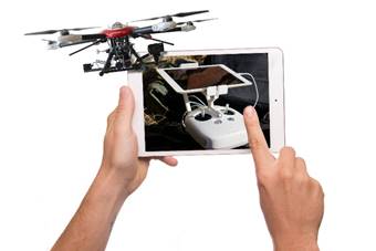
The use of drones in business
Drones are small unmanned aerial vehicles (Unmanned Aerial Vehicles) that are remotely or automatically piloted (Chyla, 2017). The history of drones dates back to the mid-nineteenth century, when on August 22, 1849, the Austrian army used unmanned balloons filled with explosives against Italian waxes (Consortiq, 2020). Since then, the development of unmanned systems has been primarily related to the defence industry, but in the last dozen or so years they have found application in the commercial sphere, especially in business services (Dronethusiast, 2019). Among the most popular, it can be indicated:
- entertainment photography and filming,
- inspections of agricultural land and buildings and structures,
- mapping and creating a spatial information system,
- environmental monitoring, including air quality monitoring,
- protection of property and persons, including the protection of public safety.
Of course, the above-mentioned applications do not exhaust the entire range of possibilities that the drone market is facing. As the examples have shown, the practical use of drones depends on the circumstances, e.g. during the COVID-19 pandemic, drones are used to monitor adherence to the principles of social distancing, transporting food for people in quarantine or sick, or disinfecting public spaces (see video: https://youtu.be/l06hhkg6xzc).
Source: Pixabay
Construction of the drone
Although the technology still provides new solutions, there are several basic elements in the construction of the drone, without which it will not fulfil its basic functions. Fig. 20 shows a general diagram of the drone structure.
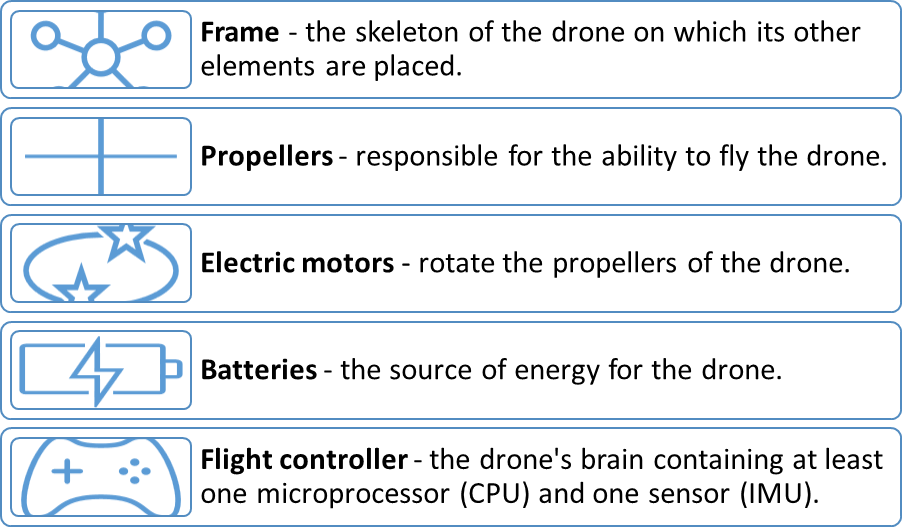
Fig. 20. Basic elements of the construction of the drone
Source: own elaboration based on (Amza et al., 2018)
Source: Pixabay
The use of sensors in drones
The possibility of using drones depends on their “stability”. To ensure it, each drone has an appropriate system of sensors that allow the drone to self-test its position. This is done using the IMU sensor (Inertial Measurement Unit). It allows the drone to obtain information about its location and movement parameters, i.e. it can be the equivalent of a human labyrinth. The IMU uses information from three sensors mounted on the drone (Botland, 2021).
In addition to these sensors, various measurement systems are commonly installed in drones, the size of which depends on the target. Fig. 21 shows the division of sensors installed in drones.
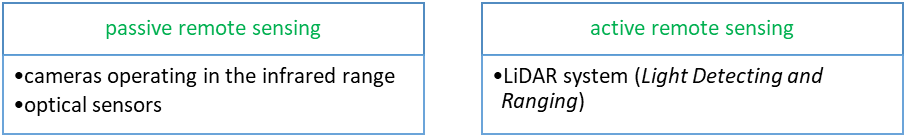
Fig. 21. Sensors installed in drones
Source: (Berner & Chojnacki, 2017)
The infrared cameras installed in drones work in a similar way to stationary thermal imaging cameras, but they offer more possibilities: they can be used on relatively large surfaces where it would be difficult to use stationary monitoring or to manually move the camera. In this way, the drone is a transporter of the camera, from which the image is sent to the computer. They are mainly used in (Europro, 2021):
- inspection of solar farms,
- building insulation control,
- location of leaks from heating networks,
- testing high voltage lines,
- border protection,
- rescue and search missions,
- control of animals living in forest areas.
LiDAR system is a remote sensing technology that uses high-speed laser pulses to map the earth’s surface (LIDAR, 2021). This system allows you to create a digital surface or a model of the examined area in high resolution. By using ultraviolet near-infrared light to image objects, it is not required that objects be illuminated by external light. This allows the system to be widely used in hard-to-reach places (e.g. mines or forests). The LiDAR system can also be used for e.g. (Flyandwatch, 2021):
- designing the course of road and rail routes, pipelines,
- registration of high-voltage lines and detection of collisions with tree crowns,
- creating flood maps,
- creating 3D models for the distribution of various objects in cities or monitoring the intensity of phenomena,
- measurement of earth mass (e.g. heaps, landfills),
- making hydrographic measurements up to a depth of 70 m,
- detection of remains of archaeological objects.
You can see more about the use of the LiDAR system in the videos:
The use of sensors in drones depends on the goal to be achieved with the use of flying equipment. The development of drone technology may bring newer and newer applications, which are currently in the testing phase.
Own project:
Preparation of a sensor infrastructure implementation plan in your own startup.